43-57 Upperkirkgate
E21
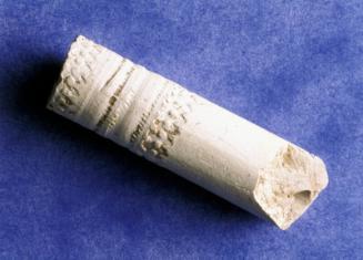
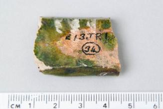
DescriptionExcavation was carried out in 1982-3 by Aberdeen City Council Archaeological Unit on the south side of Upperkirkgate. Although partly disturbed ground, the excavation produced evidence of 13th century to circa 20th century activity, including medieval pits, walls and other features. Cellarage and road widening had destroyed any traces of street frontage deposits, but remains of some 15th- to 16th-century buildings had survived. Some evidence was found of the Upper Mill, one of the burgh's mills from the 14th century onwards. A 'defensive bank' visible on Parson Gordon's map of 1661, however, was not found. Analysis of soil samples from the site indicated that a series of shallow pits and ditches may be related in some way to the medieval Upper Mill. The finds from this site are in the collections of Aberdeen Art Gallery and Museums.Location InfoNational Grid Reference: NJ 9413 0638
Easting: 394139.819598229, Northing: 806385.788124258
Postcode: AB10 1BA
Site located at the junction of Upperkirkgate and Flourmill Lane.
NotesMurray, H. (1982d) 'British Telecom trenches 1979', in Murray, J C, Exacvations in the medieval burgh of Aberdeen 1973-81, Society of Antiquaries of Scotland Monograph Series No.2. Edinburgh. Page(s): 110, 112 Roy, M. (2008a) 'Bon Accord Centre, George Street, Aberdeen City (Aberdeen parish), evaluation, watching brief and excavation', Discovery Excav Scot, New, vol. 9, 2008. Cathedral Communications Limited, Wiltshire, England. Page(s): 11-12 See Cameron, A. and Stones, J. (ed.) (2001). Aberdeen: An In-Depth View of the City's Past. Edinburgh: Society of Antiquaries of Scotland Monograph Series No. 19. 50-59, for a detailed account of the excavation. See also Dennison, E. and Stones, J. (1997). Historic Aberdeen. Edinburgh: Historic Scotland. 40-45, for more context. Reference Numbers
- NJ90NW97
- NJ90NW0112
- 20231